Best Portable GPS for Hiking 2026: Top Picks for Every Adventurer
Finding Your Way Outdoors
You’ve probably found yourself hiking in unfamiliar terrain, wondering if your phone’s GPS will hold up or if you’ll lose signal. It’s common to want a reliable, portable GPS device that can guide you safely and clearly without weighing you down.
Choosing the best portable GPS for hiking can be tricky. There are trade-offs between ease of use, battery life, screen visibility, and extra features like satellite communication. Some devices focus on ruggedness and accuracy, while others offer longer battery life or multi-system satellite support.
This article will help you understand what matters most when picking a handheld GPS for hiking. We’ll look beyond specs to the practical side of using these devices on trails, so you can find one that fits your style and needs.
What To Keep In Mind When Choosing A Hiking Gps
Not all GPS units are made for every hiker. Some are compact and lightweight, ideal for minimalist packers. Others come with larger screens and more buttons, which can be helpful in challenging weather or bright sunlight. Battery life can vary greatly, affecting how long you can rely on the device during long trips.
Another common point of confusion is the satellite systems supported. More systems can mean better accuracy and faster positioning, especially in dense forests or deep valleys. Some GPS units also include features like built-in compasses, altimeters, or even satellite messaging, but these extras usually come at a higher price.
Balancing Features And Practical Use
It’s easy to get overwhelmed by technical details. Instead, consider how you plan to use the GPS. Will you hike day trails or multi-day backcountry routes? Do you need simple navigation, or do you want to share your location with others? How important is waterproofing or ruggedness?
Thinking about these questions can help you focus on what truly matters and avoid paying for features you might never use.
Below, you’ll find a selection of hiking GPS units chosen to cover a range of uses and preferences. Each option reflects different priorities, from lightweight designs to expanded satellite support and extended battery life. This variety should help you find a device that fits your hiking habits and budget.
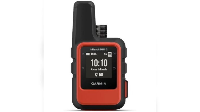
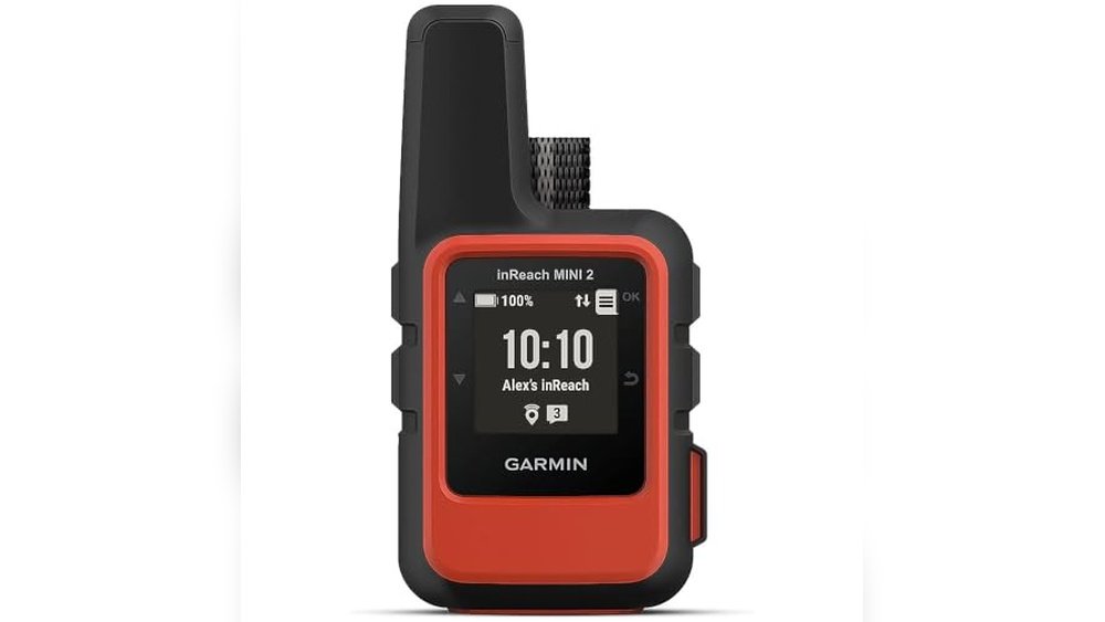
Garmin Inreach Mini 2 Satellite Communicator
This compact device ranks among the Best Portable Gps for Hiking by offering reliable global two-way messaging and SOS capability for outdoor adventurers.

The Garmin inReach Mini 2 is a lightweight handheld satellite communicator designed for hikers who need reliable communication beyond cell coverage. It enables two-way messaging and interactive SOS functions worldwide, helping you stay connected and safe on remote trails. Its Bluetooth feature also lets you sync with the Garmin Explore app for trip planning and navigation.
Using this device on a hike feels reassuring because you can share your location anytime and navigate back with TracBack routing. The digital compass provides accurate heading data even when stationary, making it easier to maintain your direction and peace of mind during outdoor adventures.
Key Navigation and Communication Features
- Compact and lightweight design ideal for hiking without added bulk
- Global two-way messaging and SOS via satellite (subscription needed)
- TracBack routing helps you navigate back to your starting point
- Digital compass provides reliable heading even when standing still
- Share your real-time location through MapShare or embedded coordinates
- Syncs with Garmin Explore app for planning and topographical maps
- Water resistant for outdoor durability
Considerations Before Buying
- Requires active satellite subscription for messaging and SOS features
- Limited screen size might reduce ease of map viewing compared to larger units
- Some regions regulate or prohibit satellite communicator usage
Ideal Use Cases for This GPS Communicator
This device is best for hikers venturing into remote areas without reliable cell service who want a lightweight way to stay connected and safe. It removes the stress of losing contact by providing global satellite communication and location sharing.
To get the most from it, ensure your satellite subscription is active before heading out and familiarize yourself with the Garmin Explore app for planning routes and syncing waypoints. This setup helps prevent navigation guesswork and enhances safety with dependable SOS capability.
If you prefer compact gear that doesn’t weigh you down, this unit fits well into minimalist hiking kits while delivering essential communication features.
| Best for | Why |
|---|---|
| Remote hiking trips | Provides global two-way satellite communication beyond cell coverage |
| Lightweight gear enthusiasts | Compact and low-weight design ideal for carrying on long hikes |
| Safety-conscious hikers | Interactive SOS and location sharing offer peace of mind in emergencies |
| Trip planners | Syncs with Garmin Explore for route planning and topographical maps |
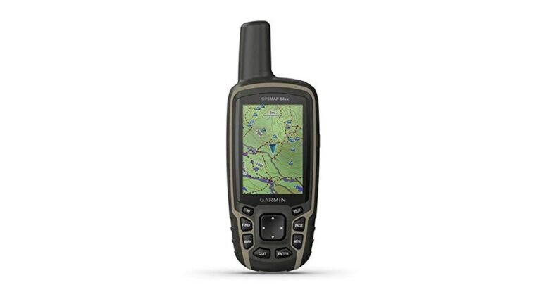
Garmin Gpsmap 65 Handheld Gps
The Garmin GPSMAP 65 stands out as one of the Best Portable Gps for Hiking with its precise multi-band technology designed for challenging outdoor environments.

The Garmin GPSMAP 65 is a button-operated handheld GPS device that helps hikers navigate with confidence even in tough terrains like dense forests or urban canyons. Its large 2.6” sunlight-readable color display ensures easy viewing outdoors, while expanded satellite support improves location accuracy.
Using this GPS feels reliable and straightforward, making it easier to plan routes and track your waypoints with the help of compatible apps. This reduces guesswork and gives peace of mind when exploring unfamiliar trails.
Key Features for Hiking Navigation
- Accurate positioning with multi-band technology in dense or challenging areas
- Sunlight-readable 2.6” color display for clear outdoor visibility
- Includes routable TopoActive and U.S. federal public land maps for detailed trail information
- Compatible with Garmin Explore app for managing routes and reviewing statistics
- Compact and lightweight for easy carrying on hikes
Considerations Before Buying
- Button-operated interface may have a learning curve compared to touchscreen models
- Maps and app compatibility require a compatible smartphone for full functionality
- Price reflects advanced navigation tech but may be higher than basic handheld GPS units
Who This GPS Works Best For
This handheld GPS is ideal for hikers venturing into areas with dense tree cover or complex terrain where reliable satellite tracking is crucial. It removes the stress of losing signal or inaccurate positioning, helping you stay on track with confidence.
To get the most from it, syncing your routes and waypoints with the Garmin Explore app beforehand can streamline your experience on the trail. The result is fewer surprises and enhanced safety during your outdoor adventures.
If you prefer a tactile interface and value precise navigation in challenging locations, this device fits your style well.
| Best for | Why |
|---|---|
| Hiking in dense forests | Multi-band satellite support improves accuracy where signals are weak |
| Exploring public lands in the U.S. | Preloaded federal public land maps aid navigation on government-managed trails |
| Users preferring physical buttons | Button-operated design allows use without relying on touchscreens |
| Route tracking enthusiasts | Garmin Explore compatibility helps manage and review hiking data easily |
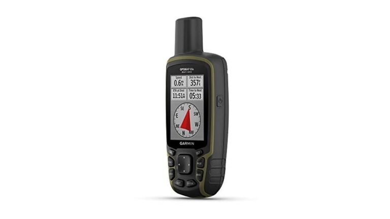
Garmin Etrex 32x Handheld Gps
This Garmin eTrex 32x is a reliable choice for the Best Portable Gps for Hiking, offering detailed maps and strong satellite tracking for trail navigation.

The Garmin eTrex 32x is a rugged handheld GPS navigator designed for outdoor adventures. It helps hikers explore with confidence by providing preloaded Topo Active maps including roads and trails, which simplifies route planning and navigation. Its support for both GPS and GLONASS satellite systems enhances tracking performance in challenging environments.
Using this device feels dependable and straightforward thanks to its sunlight-readable color display. The compact size and solid build make it easy to carry on hikes, while the ample internal memory and micro SD slot allow for extensive map downloads. It keeps you oriented so you can focus on the trail ahead.
Key Benefits for Hikers
- Preloaded topo maps with routable roads and trails for easy navigation
- Dual GPS and GLONASS satellite support for better tracking in dense terrain
- Clear, sunlight-readable color display improves visibility outdoors
- Generous 8 GB internal memory plus micro SD card slot for map storage
- Compact and rugged design suited for outdoor conditions
Considerations for Buyers
- Screen size is modest at 2.2 inches, which may limit map detail visibility
- Device weight and bulkier than smartphone GPS apps for some users
- No touchscreen interface; navigation relies on physical buttons
Who This Works Well For
This GPS unit suits hikers who prioritize reliable offline navigation with detailed maps and durable hardware. It removes the guesswork and stress of losing signal by supporting multiple satellite systems. To get the most from it, download the latest topo maps before setting out on your hike.
If you prefer a straightforward, dependable GPS device without relying on a smartphone, this is a solid option. It helps reduce surprises on trails and offers peace of mind through consistent tracking and route guidance.
| Best for | Why |
|---|---|
| Hikers exploring remote trails | Reliable satellite tracking even in challenging environments |
| Users needing detailed topographic maps | Preloaded Topo Active maps with cycling and hiking routes |
| Adventurers wanting rugged, portable gear | Compact, durable design built for outdoor use |
| Those preferring physical buttons over touchscreens | Easy button navigation avoids touchscreen issues with gloves or wet hands |
Garmin Etrex 10 Handheld Gps
The Garmin eTrex 10 is one of the best portable GPS for hiking, offering rugged reliability and worldwide basemap coverage for outdoor adventurers.

The Garmin eTrex 10 is a compact handheld GPS navigator designed for hikers and outdoor users who need dependable positioning without fuss. It includes a preloaded worldwide basemap and supports GLONASS for faster satellite acquisition, helping you stay on track in diverse environments.
Using this device feels straightforward and dependable with its clear monochrome display and long battery life. Its rugged, waterproof design means you can rely on it in various weather conditions without worrying about damage or signal loss.
Key Advantages for Hiking Navigation
- Durable, waterproof design suited for outdoor use
- Preloaded worldwide basemap for global hiking trips
- Fast GPS positioning with WAAS and GLONASS support
- Long battery life up to 20 hours with AA batteries
- Supports paperless geocaching for added adventure
- Compact size fits easily in hand or pack
Considerations Before Buying
- Monochrome 2.2-inch display lacks color mapping
- No touchscreen, requiring button navigation
- Limited to basic navigation functions without advanced mapping
When This GPS Makes Sense
This Garmin model is ideal for hikers who value simplicity and reliability over advanced features. It removes the worry of losing signal or battery mid-trip, providing a solid foundation for navigation in remote areas.
To get the best results, use high-quality AA batteries like Polaroid for maximum runtime. This device gives peace of mind on trails by tracking elevation points and waypoints, reducing guesswork and helping you estimate distances easily.
| Best for | Why |
|---|---|
| Basic hiking navigation | Preloaded worldwide basemap and reliable GPS positioning |
| Long day hikes or multi-day trips | Up to 20 hours battery life with easily replaceable AA batteries |
| Outdoor enthusiasts needing rugged gear | Waterproof to IPX7 and durable construction for harsh conditions |
| Geocaching hobbyists | Supports paperless geocaching for convenient treasure hunting |
Niesahyan Rugged Handheld Gps
The NiesahYan Rugged Handheld GPS stands out as a Best Portable Gps for Hiking, offering precise location tracking and durability for outdoor enthusiasts.

This handheld GPS is designed to help hikers navigate confidently by providing accurate location data through multi-GNSS support. Its rugged, waterproof design ensures durability in challenging outdoor conditions while the sunlight-readable 3.2″ screen allows for easy viewing even in bright environments.
Using this device feels reliable and straightforward thanks to physical buttons that work well in any weather. You can track your route and waypoints easily, and the long battery life means less worry about power during extended trips.
Key Advantages for Hiking Navigation
- Multi-GNSS support for location accuracy within 6 feet
- Water-resistant design rated IP66 for all-weather use
- Sunlight-readable 3.2″ screen enhances visibility outdoors
- Physical buttons provide dependable control in any condition
- 3-axis compass and barometric altimeter for precise navigation
- Long battery life up to 36 hours on a full charge
- Compact and lightweight for easy carrying on hikes
Considerations Before Buying
- No touchscreen interface, which may slow input for some users
- Relies on GPS technology, so dense forest cover can affect signal
- Limited additional features beyond core navigation functions
When This GPS Fits Your Hiking Needs
This handheld GPS is ideal for hikers who prioritize reliability and accuracy in rugged environments. It removes the guesswork in navigation, helping you avoid getting lost or off-route.
To get the best results, familiarize yourself with the compass and altimeter features before heading out. This device offers peace of mind through its durable build and precise location tracking, reducing surprises on the trail.
| Best for | Why |
|---|---|
| Backcountry hikers | Need reliable GPS with multi-constellation support in remote areas |
| Adventurers in varied weather | Water-resistant and rugged design withstands harsh conditions |
| Users preferring physical controls | Buttons provide better handling than touchscreens during hikes |
| Long day hikes | Extended 36-hour battery life reduces charging concerns |
Garmin Etrex Se Handheld Gps
The Garmin eTrex SE is a reliable choice among the Best Portable Gps for Hiking, offering long battery life and multi-GNSS support for challenging trails.

The Garmin eTrex SE is a handheld GPS navigator designed for outdoor hiking enthusiasts who need dependable navigation. It solves the problem of losing your way with its multi-GNSS support, which accesses several global satellite systems for better tracking in tough environments.
Using this GPS feels reassuring thanks to its sunlight-readable 2.2” display and wireless connectivity to a smartphone app for easy updates and trip planning. Its long battery life means you can rely on it for extended hikes without constant recharging.
Key Advantages for Hiking Use
- Multi-GNSS support ensures accurate tracking in dense forests and rugged terrain
- Long battery life up to 168 hours in standard mode reduces worry about power
- Sunlight-readable screen keeps routes visible even in bright daylight
- Wireless pairing with Garmin Explore app enables effortless trip planning and software updates
- Automatic geocache updates enhance outdoor adventure with live data
- Compact and lightweight for easy carrying on hikes
Considerations for Buyers
- Requires 2 AA batteries, which are not included
- Screen size is modest and may feel small for detailed maps
- Interface is functional but less modern compared to touchscreen devices
Where This GPS Excels
This GPS is ideal for hikers venturing into challenging environments where multiple satellite systems improve location accuracy. It removes the stress of losing signal and provides a dependable tool for navigation over long periods thanks to its extended battery life.
Pairing with the Garmin Explore app is a practical tip to get the most from this device, allowing you to plan routes and receive updates easily. The eTrex SE offers peace of mind through consistent performance and reliable tracking on your outdoor journeys.
| Best for | Why |
|---|---|
| Backcountry hikers | Need multi-GNSS support to track accurately in remote areas |
| Long-duration treks | Benefit from up to 168 hours of battery life without recharging |
| Day hikers in sunny conditions | Sunlight-readable display ensures clear map viewing outdoors |
| Geocaching enthusiasts | Automatic cache updates enhance the treasure hunt experience |
Key Considerations When Choosing A Handheld Gps Unit
Purpose and Usage Environment
Consider where and how you will primarily use the GPS device. Devices with satellite communication and SOS features are ideal for remote hiking or emergency situations. For general hiking and navigation, units with strong multi-GNSS support and topographic mapping may be sufficient.
Display Type and Readability
A sunlight-readable screen is important for outdoor use. Larger color displays provide better map visibility but can add to device size and battery consumption. Physical buttons improve usability in wet or gloved conditions.
Battery Life and Power Options
Long battery life is critical for extended trips. Some models support replaceable batteries, while others have rechargeable ones. Consider the availability of batteries and charging methods in your environment.
Connectivity and Software Integration
Devices that sync with smartphone apps or websites allow easier trip planning and data management. Wireless updates and geocaching support enhance the user experience but may require compatible devices.
Durability and Weather Resistance
Look for water resistance ratings and rugged designs if you expect harsh weather or rough handling. This ensures the device remains functional in various conditions.
Common Mistakes To Avoid When Selecting A Handheld Gps
- Choosing a device based solely on price without considering essential features like battery life and mapping options.
- Overlooking the importance of screen readability in bright sunlight.
- Ignoring the compatibility of the device with your smartphone or preferred mapping software.
- Underestimating the need for physical buttons for ease of use in outdoor conditions.
- Failing to verify the device’s durability and water resistance for your intended use.
Setup And Usage Tips For Handheld Gps Devices
Initial Setup
Charge or insert batteries fully before first use. Update the device firmware if possible and download maps relevant to your area. Connect to companion apps to sync routes and waypoints.
Navigation Practices
Familiarize yourself with device buttons and menu navigation. Use waypoints and track recording to mark important locations. Regularly check battery status and save your location when needed.
Maintenance
Keep the device clean and dry when not in use. Avoid exposing it to extreme temperatures. Store with batteries removed if not used for long periods to prevent corrosion.
Frequently Asked Questions
How accurate are handheld GPS units in dense forests or urban areas?
Accuracy can decrease in areas with dense tree cover or tall buildings due to satellite signal obstruction. Devices with multi-band and multi-GNSS support generally perform better in challenging environments.
Do I need a subscription for satellite communication features?
Yes, devices with two-way satellite messaging or SOS functions typically require an active subscription, which may vary by provider and region.
Can I use these GPS units for geocaching?
Many handheld GPS units support geocaching features, including waypoint storage and cache downloads, often via companion apps.
Are rechargeable batteries better than replaceable ones?
Rechargeable batteries offer convenience but may limit usage time in remote areas without charging access. Replaceable batteries provide flexibility to carry spares for extended trips.
What water resistance level should I look for?
IPX7 or higher is recommended for protection against rain and splashes. For more rugged use, look for devices rated IP66 or above.
Final Thoughts On Selecting A Handheld Gps Unit
Choosing the right handheld GPS depends on your specific needs, including the environments you will explore and the features you prioritize. Balancing display quality, battery life, durability, and connectivity will lead to a device that supports your navigation confidently. Taking time to understand these factors helps ensure your chosen GPS unit provides reliable guidance on your outdoor adventures.