Best Garmin GPS for Hiking 2026: Top Picks for Outdoor Adventures
Finding the best Garmin GPS for hiking can make a big difference on the trail. A reliable GPS keeps you on track, even in tough terrain. It offers clear maps, accurate location info, and helpful features like route planning and weather updates. Whether you’re heading out for a quick day hike or a longer adventure, having the right device adds confidence and safety. Garmin has a strong reputation for durable, user-friendly GPS units designed specifically for outdoor use. Knowing what to look for helps you pick a model that fits your hiking style and needs without any hassle.
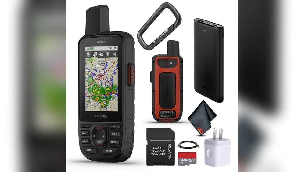
Garmin Gpsmap 67i Hiking Gps
The Best Garmin Gps for Hiking for outdoor enthusiasts who need reliable navigation and satellite communication in remote areas.

Everyday Use Insights for Hikers
- Robust satellite communication ensures connection beyond cell service areas.
- Multi-band GNSS support improves location accuracy in difficult terrain.
- Preloaded topo maps help with easy route planning and navigation.
- Long battery life means less worry about power on extended trips.
- Compact and rugged design fits comfortably in hand and withstands rough use.
- Two-way messaging allows easy contact with family or emergency services.
Considerations for Potential Buyers
- The device requires an active subscription for satellite communication features.
- Some advanced features may take time to fully learn and utilize.
- Size and weight might be noticeable if carrying ultra-light gear.
Practical Thoughts for Outdoor Navigation
This Garmin GPSMAP 67i is a solid choice for those who spend time hiking in remote or challenging environments. Its satellite messaging and SOS capabilities offer peace of mind that’s hard to match with simpler GPS units. The addition of multi-band GNSS support significantly enhances positional accuracy, which can be crucial when trails become unclear or terrain is difficult.
Using it feels intuitive once familiar, and the bright screen is easy to read in various lighting conditions. While it’s a bit heavier than basic models, the rugged build and long battery life make it a dependable companion. The need for a subscription for full satellite functionality might put off casual hikers, but for serious adventurers, it is a valuable investment.
Thoughtful Choice for Serious Hikers
This device suits hikers venturing into areas without reliable cell coverage who want dependable GPS navigation plus satellite communication. It’s ideal for those who prioritize safety and detailed mapping.
If you prefer a simple GPS without subscription costs or are focused on lightweight gear, this might not be the best fit as the device is bulkier and requires ongoing service fees.
Before heading out, spend time learning the messaging and SOS features to get the most out of the device. Remember, it’s designed to keep you connected and informed, helping you hike with confidence and less stress.
Garmin Inreach Mini 2 Satellite Communicator
For hikers seeking the Best Garmin Gps for Hiking, this compact satellite communicator offers reliable global messaging and SOS features, ideal for outdoor adventurers needing dependable communication off the grid.

Real-World Benefits and Considerations
- Lightweight and compact design fits easily in a backpack or pocket.
- Two-way messaging keeps you connected even in remote areas.
- TracBack routing helps you find your way back without confusion.
- Digital compass provides accurate heading information while stationary.
- Requires an active satellite subscription for full functionality.
- Some regions may restrict satellite communication device use.
Choosing the Right Companion for Your Hike
This device is well-suited for hikers who prioritize safety and communication beyond traditional cell coverage. It’s especially helpful for solo travelers or those venturing into remote terrain where letting loved ones track progress matters. The compact size and water resistance make it easy to carry and durable for outdoor conditions.
However, if you prefer a GPS device solely for navigation without satellite messaging, or you want a gadget without ongoing subscription fees, this might not be the best fit. Also, if you hike in areas with strict rules about satellite devices, check local regulations before relying on it.
- Ideal for backcountry hikers wanting peace of mind.
- Not suited for casual day hikers in well-covered cell areas.
- Best paired with a smartphone for trip planning and syncing.
Thoughts for Your Next Outdoor Adventure
If your hikes take you off the beaten path or into less accessible areas, this Garmin communicator offers a dependable way to stay in touch and navigate safely. Its compact form and practical features bring confidence without bulk. Keep in mind the need for a satellite subscription and local rules to ensure smooth use.
For those willing to manage these details, it’s a quiet but valuable companion that blends well with serious outdoor gear. Remember to test the device before heading out and sync your planned routes through the Garmin Explore app for a smoother experience.
Garmin Etrex 32x Handheld Gps
For outdoor enthusiasts seeking the Best Garmin Gps for Hiking, this device offers reliable navigation with detailed topo maps and rugged design.

The Garmin eTrex 32x is a rugged handheld GPS navigator built for hiking and cycling. It solves the common problem of losing your way on remote trails by offering preloaded Topo Active maps and support for both GPS and GLONASS satellites, which improves tracking in challenging environments. Its 2.2-inch sunlight-readable color display makes it easy to see your route even in bright outdoor conditions.
Using the eTrex 32x feels straightforward and reassuring. The device’s compact size and simple interface let you focus on the trail instead of fumbling with complicated controls. I found it helpful to have the micro SD card slot for additional map downloads, which adds flexibility for longer trips.
Practical Hiking Features in Use
- Clear, bright screen visible under direct sunlight
- Reliable satellite reception even in dense woods or rugged terrain
- Preloaded maps with cycling and hiking trails ready to use
- Expandable memory for extra maps or data storage
- Compact and lightweight for easy carrying on long hikes
Considerations Before Buying
- Basic display resolution might feel limited compared to smartphones
- No touchscreen, navigation relies on button controls
- Maps require occasional updates which need a computer connection
Choosing This GPS for Your Trail
This device fits well for hikers and outdoor adventurers who want a dependable GPS with detailed maps and robust tracking capabilities. It is particularly suited to those who spend time off the beaten path and need a tool that performs reliably under varied conditions.
However, if you prefer a device with a modern touchscreen or want integrated smartphone features, this might feel a bit dated. Also, if updating maps or handling micro SD cards sounds inconvenient, consider that before buying.
- Ideal for serious hikers needing rugged, accurate navigation
- Not the best choice for casual users expecting smartphone-like interfaces
- Good for users who want a device focused solely on GPS without distractions
Thoughts on Garmin eTrex 32x for Hiking
The Garmin eTrex 32x offers a solid balance of functionality and durability for those focused on trail navigation. Its support for GPS and GLONASS satellites provides confidence in tracking where other devices might struggle. One trade-off is its simpler screen and button controls, which some may find less intuitive than newer models.
For those who appreciate straightforward tools designed specifically for outdoor use, this GPS is a dependable companion. If you can live with a non-touch interface and occasional map updates, it will serve you well on the trail.
How to Decide If This Fits Your Hiking Needs
If you plan to explore challenging terrain and want a device that won’t rely on cell coverage or smartphone batteries, this handheld GPS is worth considering. It suits those who value reliability and clear maps over flashy features.
On the other hand, if you want a multi-purpose device with apps and a touchscreen, this may not meet your expectations. Before purchasing, think about how much you want to interact with your GPS while hiking.
One practical tip: take some time to familiarize yourself with the button navigation and map features before heading out. This preparation will help you use the device confidently on your hikes.
Overall, the Garmin eTrex 32x is a steady choice for hikers looking for a no-nonsense, rugged GPS that helps keep you on track without unnecessary complexity.
Garmin Gpsmap 65s Hiking Gps
If you’re looking for the Best Garmin Gps for Hiking, this model suits outdoor enthusiasts who need reliable navigation in tough terrains.

Everyday Hiking Navigation Made Simple
The Garmin GPSMAP 65s is a handheld GPS device designed to help hikers navigate challenging environments with confidence. It features expanded satellite support and multi-band technology, which ensures accurate positioning even in dense forests or steep canyons where signals often weaken.
Using this GPS feels straightforward thanks to its button-operated interface and clear 2.6-inch color display. The built-in altimeter and compass add useful data without needing a smartphone. I found it saves time by reducing guesswork on trails, letting me focus more on the hike itself.
Who Finds This Useful and Who Might Look Elsewhere
This Garmin unit is ideal for hikers who want a rugged, dependable GPS with precise location tracking and offline topo maps. It suits those who prefer tactile controls over touchscreen devices, especially in wet or cold conditions.
However, users looking for a smartwatch-style GPS or those wanting extensive smartphone integration might find this less convenient. The button interface may feel slow for quick menu changes to some.
- Clear display visible in sunlight
- Reliable navigation in tricky terrain
- Offline topo maps included for U.S. public lands
- Long battery life without frequent charging
- Interface can be slower than touchscreen models
- No built-in smartphone notifications
- May be bulky for very lightweight hiking kits
Thoughts for the Practical Hiker
If you hike regularly in remote or rugged areas, this Garmin offers dependable navigation that won’t easily fail you. Its physical buttons and strong satellite reception make it a solid choice for serious outdoor use. On the other hand, if you prefer an all-in-one smartwatch or want advanced app syncing, this device might feel limited.
When using it, take some time to familiarize yourself with the button layout to move through menus efficiently. This will make your experience smoother and less distracting on the trail. Overall, it’s a reliable tool for those who value precision and durability without unnecessary extras.
Garmin Etrex 10 Handheld Gps
For hikers seeking the Best Garmin Gps for Hiking, this device offers reliable navigation and durability for outdoor adventures.

Navigation Essentials for Hiking
- Preloaded worldwide basemap for easy orientation anywhere.
- WAAS-enabled GPS with GLONASS support ensures fast, accurate positioning.
- Waterproof design protects against weather and outdoor conditions.
- Long battery life up to 20 hours for extended trips.
- Monochrome display is clear and readable under sunlight.
Points to Consider Before Buying
- Screen is monochrome, so no detailed color maps.
- Basic interface might feel dated compared to newer models.
- Requires AA batteries which need to be carried as spares.
Thoughts for Hikers Choosing a GPS
The Garmin eTrex 10 is straightforward and built to last in rugged conditions. It solves the core problem of navigation without unnecessary complexity. Its preloaded global basemap means you don’t have to worry about downloading maps or connectivity. In practical use, it feels dependable. The GPS locks quickly and holds signal well, even in dense forests or valleys. While the screen is simple, it’s easy to read in bright daylight. This device gives confidence to hikers who prioritize reliability and ease over flashy features.Garmin Etrex Se Gps Navigator
The Garmin eTrex SE is a solid choice for hikers seeking the Best Garmin Gps for Hiking who need reliable navigation in diverse environments.

What to Expect on the Trail
- Easy-to-read 2.2” screen works well even in bright sunlight.
- Very long battery life supports multi-day hikes without worry.
- Multi-GNSS support improves accuracy in dense forests or mountains.
- Wireless updates and trip planning via the Garmin Explore app add convenience.
- Compact and lightweight design makes it comfortable to carry all day.
Considerations Before Buying
- Requires AA batteries, so you need to carry spares for extended trips.
- Screen size is modest; detailed maps might be better viewed on a larger device.
- Wireless features need a compatible smartphone to unlock full potential.
A Thoughtful Choice for Outdoor Navigation
The Garmin eTrex SE offers reliable navigation for hikers who venture into challenging environments. Its support for multiple satellite systems ensures better tracking where GPS alone might struggle. The long battery life is a practical benefit for those on extended trips or in remote areas. While the device is straightforward to use, some may find the small screen limiting for detailed map views. Also, the reliance on AA batteries means you should plan ahead to avoid running out of power. Still, pairing it with the Garmin Explore app enhances its usefulness without complicating the core experience.Finding the Right Fit for Your Hikes
This GPS unit suits hikers who prioritize battery life and rugged reliability over flashy features. If you spend days off-grid or in dense terrain, this device supports confident navigation without frequent recharging. However, if you want a touchscreen or integrated mapping without a phone, this might feel basic. Keep spare batteries handy, and use the app for planning before you head out. That way, you get the most from this practical and durable handheld GPS. It’s a dependable tool that performs well where it counts, providing steady guidance without distractions.Garmin Gpsmap 67i Handheld Gps
The Best Garmin Gps for Hiking for outdoor enthusiasts who want reliable navigation and emergency communication in remote areas.

Features That Matter on the Trail
- Large 3” sunlight-readable color display for clear visibility outdoors
- Two-way messaging and SOS via global Iridium satellite network for safety
- Preloaded TopoActive maps and multi-band GNSS support for accurate navigation
- Weather updates and Geocaching Live when connected to a smartphone
- Compact and rugged design weighing just over half a pound
The Garmin GPSMAP 67i is a handheld GPS device designed to keep hikers connected and on track. It solves the problem of losing signal or being unreachable in remote locations by using satellite technology for two-way messaging and emergency SOS. Its large, sunlight-readable screen simplifies map reading even under bright conditions.
Using the device feels reassuring thanks to its reliable positioning and communication features. The pairing with a smartphone adds convenience without complicating the core experience. I found it easy to navigate and appreciate the peace of mind the interactive SOS function brings during long hikes.
Who Benefits Most from This GPS?
This GPS is ideal for serious hikers who venture into remote or challenging terrain and want a dependable tool that also offers emergency communication. It suits those who value clear mapping and reliable satellite connections over simpler devices.
However, casual day hikers or those on well-marked trails might find this device more advanced and costly than needed. If you prefer a lighter gadget without satellite messaging features, this might not be the best fit.
- Best for multi-day or backcountry hiking trips
- Great for hikers who want real-time SOS and messaging
- Not the top choice for short or urban hikes
Thoughts on Choosing This Garmin GPS
The Garmin GPSMAP 67i offers a solid balance of navigation and safety features that bring confidence to extended outdoor trips. Its satellite messaging is a standout, though it requires an active subscription, which adds ongoing cost and complexity.
It’s a rugged device that handles tough environments well, but the screen size and weight make it less pocket-friendly than simpler models. For those who need dependable positioning and emergency options, it’s a sensible choice.
Keep in mind that using satellite communication depends on regulations in your area, so check local rules before relying on this feature.
Garmin Montana 710 Handheld Gps
For hikers seeking the Best Garmin Gps for Hiking, the Garmin Montana 710 offers rugged reliability and detailed maps ideal for outdoor navigation.

The Garmin Montana 710 is a rugged handheld GPS navigator designed for outdoor enthusiasts who need reliable navigation in varied environments. It solves the problem of losing your way by combining a large, glove-friendly 5-inch touchscreen with detailed TopoActive maps and downloadable satellite imagery, making it easy to plan routes on roads and trails.
Using it feels intuitive and reassuring, even in harsh conditions, thanks to its MIL-STD 810 rating for durability and IPX7 water resistance. The expanded memory lets you carry extra maps, and the sharp display means I can quickly identify landmarks and waypoints without fumbling, which saves time and reduces stress during hikes.
Real-World Hiking Insights
- The large touchscreen allows easy operation with gloves on, which is helpful in cold weather.
- Preloaded TopoActive maps provide detailed trail information right out of the box.
- Durability standards mean it can handle rough conditions without worry.
- Wi-Fi download capability simplifies updating maps and adding new routes.
- High-resolution satellite imagery aids in visualizing terrain and landmarks.
- The device is somewhat bulky compared to smaller GPS units.
- Additional map content and premium features require separate subscriptions or purchases.
- Battery life may be shorter with continuous use of high-resolution mapping.
Thoughtful Navigation Tool for Serious Hikers
The Garmin Montana 710 fits well with hikers who prioritize ruggedness and detailed mapping in one device. It is especially useful for those venturing into remote areas where reliability is critical. However, if you prefer a lighter GPS or want all-inclusive mapping without extra costs, this might feel a bit heavy or complicated.
Consider pairing it with extra batteries or a portable charger for longer trips. The device offers a reassuring level of control and confidence when out on trails, helping you focus more on the experience and less on navigation worries.
Garmin Gpsmap 64sx Hiking Gps
For outdoor enthusiasts seeking the Best Garmin Gps for Hiking, this handheld GPS device offers reliable navigation and essential tools.

Navigation Essentials for Hikers
- Rugged and water-resistant body stands up to tough outdoor conditions
- Preloaded TopoActive maps help you follow trails and routes with confidence
- High-sensitivity GPS receiver ensures accurate location tracking in remote areas
- 3-axis compass and barometric altimeter provide vital orientation and elevation data
- Up to 16 hours of battery life supports extended trips
Points to Consider
- Display is sunlight-readable but relatively small at 2.6 inches
- Wireless features like Bluetooth are limited to certain models only
- Maps preloaded only for U.S. and Australia, which may limit global use
The Garmin GPSMAP 64sx is designed for hikers who want dependable navigation without fuss. Its rugged design and detailed topographic maps make it easier to stay oriented in the wild. The high-sensitivity receiver keeps your position accurate even under tree cover or in deep valleys.
Using this device feels straightforward. The button controls work well even with gloves on, and the compass and altimeter add useful layers of information for route planning. I found it reassuring to have a GPS that doesn’t rely solely on a phone’s battery or signal.
Considering Your Outdoor Needs
This GPS suits hikers who spend serious time outdoors and need a durable, reliable device with solid navigation features. It’s ideal for those exploring U.S. trails where the preloaded maps shine.
If you’re looking for a larger screen or global map coverage, or if wireless syncing is critical, you might want to consider other options. Casual users or those expecting smartphone-like interfaces may find it less intuitive.
- Great for extended hikes and backcountry navigation
- Not suited for international travel outside covered regions
- Ideal for users comfortable with button-operated devices
Thoughtful Choice for Focused Hikers
If your priority is a tough, no-nonsense GPS that delivers accurate location and route info on U.S. trails, this Garmin is a solid pick. It may not have all the bells and whistles, but it performs well in essential areas.
Those needing global coverage or a bigger, more modern display might want to explore other models. For those who do choose this, a practical tip is to familiarize yourself with the button layout before heading out, so you can operate it smoothly in the field.
Overall, it offers peace of mind when navigating less-traveled paths, letting you focus more on the hike itself than on navigation worries.
Garmin Montana 760i Gps Navigator
The Best Garmin Gps for Hiking for outdoor enthusiasts who need reliable navigation and emergency communication in remote areas.

The Garmin Montana 760i is a rugged handheld GPS designed for hikers and adventurers who venture beyond cellular coverage. It combines precise navigation with built-in inReach satellite communication, allowing users to send two-way texts and trigger SOS alerts even in remote areas. The 5-inch touchscreen and integrated 8MP camera add practicality for capturing waypoints and mapping routes.
Using this device feels reassuring, especially when exploring off-grid locations. The touchscreen responds well even with gloves, and the satellite messaging provides peace of mind in emergencies. I found it intuitive to operate, which helps save time navigating unfamiliar trails without second-guessing my position.
Usability and Practical Considerations
- Clear 5” touchscreen works well with gloves and bright sunlight
- inReach technology ensures communication beyond cell range
- Integrated camera tags photos with GPS coordinates
- Includes topo maps and road maps for versatile navigation
- Rugged build suitable for harsh outdoor conditions
- Requires active inReach subscription for satellite messaging
- Device weight is noticeable during long hikes
- Additional map downloads may cost extra
Thoughts on Who Will Benefit Most
This GPS unit suits serious hikers and backcountry travelers who prioritize safety and connectivity where phones fail. Its satellite communication features make it ideal for remote expeditions or extended trips. Conversely, casual day hikers or those sticking to well-marked trails might find it more device than needed and could prefer lighter, simpler options.
For anyone planning multi-day treks in isolated areas, this device offers a strong balance of navigation and emergency readiness. However, users should be prepared for the subscription cost and the slight bulk it adds to gear.
Guidance for Choosing This GPS
If you often hike in areas without cell service and value having an SOS function, the Garmin Montana 760i is a sensible choice. Those wanting a rugged, all-in-one navigator with communication capabilities will appreciate its feature set. On the other hand, if you prefer minimalist gear or don’t need satellite texting, this may feel heavy and pricey.
Before buying, consider your typical hiking environments and whether satellite messaging adds meaningful security for you. If it does, this device can be a reliable companion that helps you stay oriented and connected with confidence.
Narrowing Down Your Best Garmin Gps For Hiking
Choosing a Garmin GPS for hiking can feel overwhelming with so many options. Start by thinking about where you’ll mostly use it—remote backcountry or well-marked trails. Battery life matters if you plan long trips without charging opportunities. Consider if you need satellite communication for safety beyond cell coverage. Most people miss checking if the device syncs easily with their smartphone for trip planning. Size and weight affect comfort, especially on long hikes. Lastly, look at screen readability in bright sunlight.
The 30-second Checklist
- Does it have reliable GPS accuracy in dense forests or mountains? Yes / No
- Can the battery last through your longest planned hike? Yes / No
- Is the device easy to operate with gloves or in wet conditions? Yes / No
- Does it support offline maps for areas without cell signal? Yes / No
- Can you send or receive messages in remote locations? Yes / No
- Is the screen readable under direct sunlight? Yes / No
Regret Prevention When Choosing A Garmin Gps
Regret #1: Buying a device with insufficient battery life. Fix this by matching battery specs with your longest outing and bringing extra power if needed.
Regret #2: Overlooking satellite messaging features. Avoid this by selecting models with inReach technology if you hike in areas without cell coverage.
Regret #3: Ignoring ease of use in harsh conditions. Choose units with glove-friendly buttons and waterproof ratings to prevent frustration on the trail.
Quick Pick Table For Best Garmin Gps For Hiking
| If you want… | Look for this | Avoid this |
|---|---|---|
| Long battery life for extended trips | Garmin GPSMAP 67i with 425-hour battery | Devices with less than 20 hours battery life |
| Compact and lightweight device | Garmin inReach Mini 2 | Bulkier handhelds with large screens |
| Satellite communication and SOS features | Models with inReach satellite tech | GPS only units without satellite messaging |
| Easy-to-read screen in sunlight | Garmin GPSMAP series with sunlight-readable color display | Monochrome or low-resolution displays |
| Simple button navigation over touchscreen | Garmin eTrex 32x or GPSMAP 65s | Touchscreen-only models in cold or wet conditions |
Real-life Setup And Usage Tips For Garmin Hiking Gps
- Before your hike, download offline maps and update the device firmware via Wi-Fi or Garmin Explore app.
- Practice using the SOS and messaging functions so you know how to activate them in emergencies.
- Calibrate the compass and altimeter regularly to maintain accurate readings.
- Carry spare batteries or a portable charger if your model uses replaceable batteries or supports USB charging.
- Store the GPS in an accessible spot on your pack for quick glances while hiking.
Best Garmin Gps For Hiking Faqs
Can I pair my Garmin GPS with my smartphone?
Yes, many Garmin GPS units support Bluetooth pairing with compatible smartphones. This allows syncing waypoints, routes, and accessing maps via the Garmin Explore app.
Are these Garmin GPS devices waterproof?
Most Garmin handheld GPS units are water-resistant or waterproof to varying degrees. Check the specific IP or MIL-STD rating to ensure suitability for your hiking conditions.
How long does the battery typically last during hiking trips?
Battery life varies by model and usage. Some devices last up to 425 hours, while others offer around 20 hours. Consider your trip length and whether you can recharge on the go.
Do Garmin GPS units require a subscription for maps or features?
Basic maps are usually preloaded, but some advanced features like satellite messaging require an active subscription. Always verify subscription needs before purchase.
Is the screen readable in bright sunlight?
Garmin devices designed for hiking generally have sunlight-readable color displays. This ensures you can view maps clearly in outdoor conditions.
Can I use these GPS devices for geocaching?
Yes, many Garmin handheld GPS units support geocaching features, including paperless geocaching and cache details when synced with Garmin apps.
What should I do if my Garmin GPS loses signal?
Try moving to an open area with a clear view of the sky. Some models support multi-GNSS systems for better accuracy in challenging environments.
Final Thoughts On Choosing The Best Garmin Gps For Hiking
Finding the best Garmin GPS for hiking depends on your specific needs like battery life, communication features, and ease of use. Keep your typical hiking environment and trip duration in mind when making your choice.
If you are unsure, the tie-breaker is often whether you want satellite messaging capabilities for extra safety in remote areas.