Best GPS for Hiking 2026: Top Reliable Devices for Outdoor Adventures
Finding the best GPS for hiking can make a big difference on the trail. It’s not just about tracking your route, but also about safety and ease of use. A good hiking GPS should be reliable, easy to read, and tough enough to handle rough conditions. Whether you’re going on a short day hike or a multi-day adventure, having the right device helps you stay on course without stress. The best GPS units combine clear maps, long battery life, and useful features like waypoints and altimeters. Picking the right one means less worry and more time enjoying the outdoors.
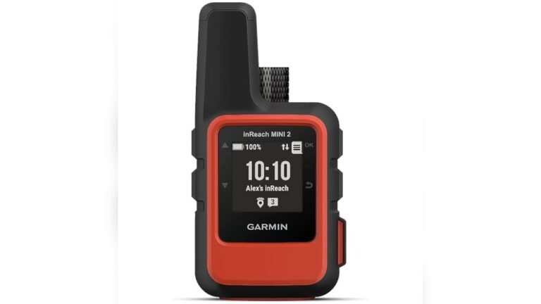
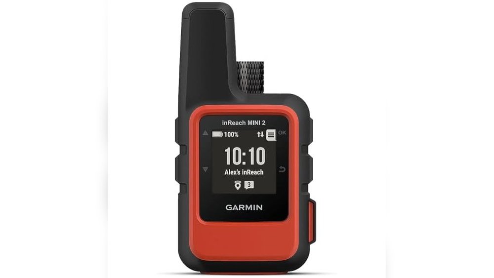
Garmin Inreach Mini 2 Satellite Communicator
The Best Gps for Hiking for adventurers who need reliable global communication and navigation in remote areas.

Daily Use Insights for Hikers
- Compact and lightweight design fits easily in hand or gear without adding bulk.
- Global two-way messaging keeps you connected even off-grid with satellite coverage.
- TracBack routing helps you navigate back to your starting point safely.
- Syncs with Garmin Explore app for simple trip planning and waypoint creation.
- Water resistant, so it holds up well in damp or rainy conditions.
Considerations Before Buying
- Requires an active satellite subscription for messaging and SOS features.
- Limited screen size means detailed map viewing is better done on your smartphone.
- Some users might find the digital compass less intuitive when stationary.
Thoughts on the Garmin inReach Mini 2
This device is a solid choice for hikers who value staying connected in remote areas where cell service is unavailable. Its small size and lightweight feel make it easy to carry without distraction. The TracBack feature provides reassurance by guiding you back safely, which is a key benefit for solo hikers or those exploring unfamiliar trails.
On the downside, the need for a satellite subscription adds ongoing cost, and the limited interface might not satisfy users wanting detailed maps on the device itself. Still, pairing it with the Garmin Explore app eases these limitations by offloading planning and map details to your phone.
Who Will Appreciate This Device
This unit fits best for serious hikers and outdoor explorers who often venture beyond cell coverage and want a compact, reliable way to communicate and navigate. Its durable, water-resistant design and global satellite messaging make it a dependable companion for extended trips or remote adventures.
It’s less suitable for casual day hikers who rarely leave well-mapped areas or who prefer devices with larger displays and built-in topographic maps. Those looking to avoid subscription fees might also want to consider alternatives.
- Great for backcountry hiking and remote expeditions
- Ideal for solo travelers needing emergency SOS capability
- Not recommended if you want a full-featured GPS with large screen maps
- Requires comfort with managing a satellite service plan
A Clear Choice for Confident Navigation
If you often hike in areas without reliable cell service and want a trustworthy way to send messages or call for help, the Garmin inReach Mini 2 is worth considering. Its lightweight form and TracBack routing add practical value without complicating your gear. However, keep in mind the ongoing subscription and device interface limits.
Before buying, think about how much you’ll rely on satellite communication and whether pairing it with the Garmin Explore app fits your planning style. For those who prioritize safety and connectivity in the backcountry, this device offers quiet confidence on the trail.
Garmin Etrex 32x Handheld Gps
For hikers needing a reliable, rugged device, this is one of the best GPS for hiking to navigate trails confidently.

Features That Matter on the Trail
- Rugged design built to handle rough outdoor conditions
- Sunlight-readable color display for easy viewing under bright skies
- Supports GPS and GLONASS for better satellite tracking in dense areas
- Preloaded Topo Active maps include trails and roads relevant to hikers
- Expandable storage allows for more maps and data
The Garmin eTrex 32x is a handheld GPS unit designed specifically for outdoor use. It helps hikers stay on course by providing detailed topo maps and robust satellite tracking that works well even in challenging environments like thick forests or deep valleys.
Using it feels straightforward. The screen is clear in daylight, and the device fits comfortably in hand. I found it reliable for long hikes, giving peace of mind without extra bulk or complexity.
Choosing This GPS for Your Hiking Needs
This unit is ideal for hikers who want a simple, rugged GPS without unnecessary extras. It fits well for those who need dependable navigation support on varied trails and value a readable screen outdoors.
It might not suit users looking for touchscreen interfaces or integrated smartphone features. Also, if you prefer a lightweight device for ultra-light hiking, its size and weight could be a drawback.
- Best for traditional hikers valuing durability and map detail
- Less suited for tech enthusiasts wanting connected apps
- Great for multi-day trips needing reliable battery life
- Not ideal if minimal device weight is a priority
Final Thoughts on the Garmin eTrex 32x
If you often hike in areas with limited cell coverage and want a dependable GPS, this device is a solid choice. It offers clear navigation and solid build quality that helps you focus on the trail, not the tech.
Those who want smartphone integration or a sleeker design might find it too basic or bulky. Still, the eTrex 32x’s straightforward functionality makes it easy to use for anyone serious about hiking safety.
One tip: take time to preload maps for your routes to get the most from its features. Overall, it provides quiet confidence on the trail without unnecessary distractions.
Niesahyan Rugged Handheld Gps
If you are looking for the Best Gps for Hiking that offers durability and precise navigation, this device from NiesahYan is suited for outdoor enthusiasts who want reliable location tracking in tough conditions.

What to Expect on the Trail
- Clear and bright 3.2″ screen remains visible even under direct sunlight.
- Multi-GNSS support ensures accurate positioning within about 6 feet.
- Water-resistant design (IP66 rating) stands up to rain and splashes.
- Physical buttons provide reliable control without needing a touchscreen.
- Long battery life—up to 36 hours—reduces worry on extended hikes.
Considerations Before Purchase
- Compact size might feel small for users preferring larger displays.
- No smartphone connectivity or app integration for advanced mapping.
- Navigation depends on GPS signals; dense forest or deep canyons may affect accuracy.
Thoughts on the NiesahYan Handheld GPS
This GPS unit balances ruggedness with simplicity, making it a solid choice for hikers who want dependable navigation without extra complexity. The physical buttons and readable screen work well in varied conditions, including bright sunlight and wet weather. I appreciated how the device felt sturdy and easy to operate on the trail, helping me stay confident about my location.
One trade-off is the lack of smartphone syncing or detailed map downloads beyond the built-in USA topo map, which might limit users wanting more customization. Still, the basic features are well executed for straightforward hiking needs.
Finding the Right Fit for Your Hiking Gear
This handheld GPS suits hikers who prioritize durability and accurate positioning in challenging environments. It’s ideal for those who prefer a dedicated device with physical controls over smartphone apps. The long battery life and water resistance make it practical for multi-day trips or wet conditions.
However, if you want advanced mapping features, live tracking, or smartphone integration, this might not meet your expectations. Its straightforward design focuses on core navigation tasks rather than extra digital connectivity.
- Great for solo hikers or small groups needing reliable, rugged navigation.
- Not recommended for users wanting extensive map customization or app syncing.
- Compact size fits easily in hand or pack without added bulk.
Guidance for Potential Buyers
If your hikes often take you into rough terrain or variable weather, this GPS offers a dependable way to stay oriented without fuss. It’s a practical tool for those who want clear, accurate location data and physical buttons that work well even with gloves or wet hands.
On the other hand, if you depend heavily on smartphone apps or require very detailed mapping, you may find this device somewhat limited. Before buying, consider your navigation style and whether straightforward GPS tracking aligns with your needs.
Overall, it’s a solid pick for hikers who value simplicity, durability, and precise positioning. The device’s long battery life and rugged design provide reassurance on the trail, letting you focus more on the experience than your gear.
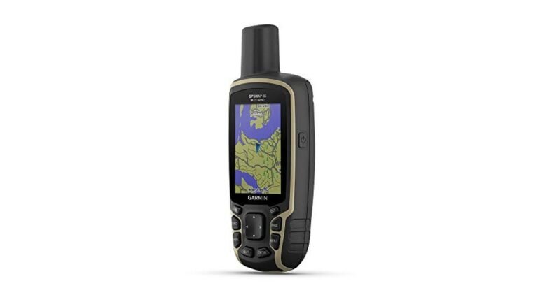
Garmin Gpsmap 65 Handheld Gps
For hikers seeking the Best Gps for Hiking, the Garmin GPSMAP 65 offers reliable navigation for those venturing into challenging terrain.

Everyday Use Insights for Hiking GPS
- Large 2.6” sunlight-readable color display keeps the map clear even in bright daylight.
- Expanded satellite support ensures accurate location tracking in dense forests and rugged terrain.
- TopoActive and public land maps help with detailed route planning and land navigation.
- Button-operated design works well with gloves or wet hands, avoiding touchscreen issues.
- Seamless integration with Garmin Explore app allows easy management of waypoints and tracks.
Considerations Before You Buy
- Relies on button controls which might feel slower compared to touchscreens for some users.
- Device size and weight are moderate; might feel bulky for minimalist hikers.
- Mapping features are U.S.-focused, which may limit use internationally.
Who Will Appreciate This GPS and Who Might Look Elsewhere
This GPS fits best for hikers who need dependable location accuracy in tough environments and prefer physical buttons over touchscreens. The multi-band satellite support is a strong point for those trekking through thick woods or urban canyons where signal can be unreliable.
Those who want a lighter, more compact unit or primarily international maps might find this less suitable. Also, if you prefer touchscreen navigation, the button interface may slow you down.
Thoughts for Potential Buyers
If you hike frequently in areas with dense trees or challenging landscapes, this Garmin GPSMAP 65 provides confidence and clarity in your navigation. It’s a solid choice for anyone valuing accuracy and ruggedness over lightweight design. However, if you prefer a GPS with touchscreen or broader global mapping, consider other options.
When using it, take a moment to familiarize yourself with the button layout before heading out. This will help you navigate menus smoothly on the trail. Overall, it’s a dependable tool that will not let you down when you need it most.
Garmin Etrex 10 Handheld Gps Navigator
If you are looking for the best GPS for hiking that offers reliable navigation and simplicity, this Garmin eTrex 10 is a solid choice for outdoor enthusiasts and casual hikers alike.

What to Expect on the Trail
The Garmin eTrex 10 is a handheld GPS unit designed to help hikers navigate with confidence. It comes preloaded with a worldwide basemap and supports GLONASS satellites, which means it locks onto your position quickly and maintains a reliable signal even in dense forests or rugged terrain. Its waterproof design adds peace of mind for outdoor use.
Using this device feels straightforward and dependable. The monochrome display is simple but clear, and the long battery life means you won’t worry about power on longer hikes. It’s easy to mark waypoints and track elevations, which helps in planning your route and estimating distances without fuss.
Real-World Pros and Cons
- Rugged and waterproof, suited for tough hiking conditions
- Quick GPS fix with WAAS and GLONASS support
- Long battery life up to 20 hours on two AA batteries
- Simple interface that keeps navigation hassle-free
- Limited screen size and monochrome display may feel outdated
- No advanced mapping or touchscreen features
Choosing This GPS for Your Adventures
This GPS fits best for hikers who want a durable, no-nonsense device that works reliably in the outdoors without extra bells and whistles. It’s ideal if you value battery life and straightforward navigation over flashy features.
If you prefer detailed maps, color screens, or smartphone-like interfaces, this model might feel limiting. It’s less suited for tech-heavy users or those needing extensive route planning tools.
- Great for casual to moderate hikers and geocachers
- Perfect for those prioritizing ruggedness and battery life
- Not recommended for tech-savvy users wanting advanced mapping
A Practical Perspective for Hikers
For anyone seeking the best GPS for hiking that balances reliability and simplicity, the Garmin eTrex 10 offers a dependable companion on the trail. It’s easy to operate, keeps running for long hours, and handles rough environments well.
While it lacks modern touchscreen convenience and detailed maps, it gives you the essentials without distraction. If you want a device that just works and doesn’t require frequent charging, this is worth considering. Remember to carry spare AA batteries, and you’ll have a steady guide for many hikes.
Garmin Gpsmap 65s Hiking Gps
The Garmin GPSMAP 65s is a solid choice for outdoor enthusiasts looking for the Best Gps for Hiking, especially those who need reliable navigation in tough environments.

How It Works on the Trail
This handheld GPS device offers dependable location tracking by using expanded global navigation satellite systems combined with multi-band technology. It’s designed to perform well even in dense forests, urban canyons, and rugged terrain where GPS signals often struggle.
In use, the 2.6-inch sunlight-readable color display makes it easy to see your route at a glance. The device feels sturdy and straightforward, with physical buttons that work well even with gloves on. It gives a sense of confidence knowing you can rely on its compass and altimeter features without fuss.
Everyday Use and Considerations
- Clear display that stays visible in bright daylight.
- Accurate positioning in challenging environments.
- Physical buttons reduce accidental input compared to touchscreens.
- Integrated altimeter and compass aid navigation without extra tools.
- Syncs with Garmin Explore app for easy planning and review.
- Some users might find the button layout takes time to get used to.
- Screen size is modest, which may limit map detail visibility.
- Weight and bulkier than smartphone GPS apps.
Thoughts on Suitability
The Garmin GPSMAP 65s fits those who prioritize precise outdoor navigation without depending on a smartphone’s battery or signal. It’s ideal for hikers venturing into remote or difficult terrain where reliable satellite reception is crucial.
However, casual hikers or those preferring touchscreen interfaces might find it less intuitive. If you want a lightweight, compact device with fewer physical controls, this may feel too bulky or complex.
- Great for serious hikers and backcountry adventurers
- Not the best choice for casual day hikes or minimal gear setups
- Useful for those needing detailed topographic maps and land data
Practical Insight for Buyers
If you often hike in remote areas or dense forests, this GPS will provide dependable location and navigation support. It requires some time to get familiar with the button controls but rewards with precision and durability.
Skip this if you want a simple, touchscreen GPS or primarily hike where smartphone GPS is sufficient. Remember, pairing it with the Garmin Explore app can enhance your experience by allowing route planning and tracking from your phone.
Garmin Gpsmap 67i Handheld Navigator
The Garmin GPSMAP 67i is a strong choice for anyone seeking the Best Gps for Hiking, especially those who value reliable satellite communication and detailed mapping.

Key Features for Outdoor Navigation
| Satellite Communication | Two-way messaging and SOS via Iridium network |
| Display | Large 3” sunlight-readable color screen |
| Mapping | Preloaded TopoActive maps with satellite imagery |
| Weight & Size | Compact and lightweight at about half a pound |
The Garmin GPSMAP 67i is a handheld GPS device designed for hikers and outdoor enthusiasts who want reliable navigation combined with satellite communication. Its standout feature is the built-in inReach technology, which enables two-way messaging and emergency SOS, providing a layer of safety when venturing into remote areas. The large sunlight-readable display makes map reading straightforward even under bright conditions.
Using this device feels reassuring and efficient. Navigating with preloaded TopoActive maps and multi-band GNSS support helps maintain confidence on trails. Pairing with a smartphone adds convenience for weather updates and trip planning. Despite its rugged build, it remains compact enough for extended hikes without feeling cumbersome.
Who Benefits Most from This GPS
This GPS unit fits hikers who often travel in areas without cell service and want peace of mind through satellite communication. It is ideal for solo adventurers or groups needing reliable location tracking and emergency contact options. The detailed mapping and weather features also assist in trip planning and route adjustments.
It may not suit casual day hikers who prioritize simplicity and lower cost, as the subscription for satellite services and device complexity could be unnecessary. Those who prefer minimal gadgets might find the extra features more than they need.
- Great for remote and backcountry hiking
- Useful for those valuing safety features
- Compact and rugged design
- Requires subscription for full satellite functionality
- Not a basic GPS for casual use
Practical Insight for Choosing This GPS
If you hike in areas where cell coverage is limited, this device offers reliable navigation plus the ability to send and receive messages via satellite. Its SOS function adds a critical safety net. However, be prepared for the subscription cost that comes with satellite service.
For those comfortable managing a more advanced device, it can save time and provide confidence on long treks. If you don’t need satellite communication, simpler models might be better. Overall, it’s a solid tool for serious hikers who want comprehensive features without unnecessary complexity.
Garmin Gpsmap 67i Handheld Gps
If you want the Best Gps for Hiking, especially for serious outdoor adventurers needing reliable navigation and communication, this Garmin device fits well.

The Garmin GPSMAP 67i is a rugged handheld GPS device that combines precise navigation with satellite communication. It addresses the common problem of losing connection or location tracking in remote or challenging hiking environments. Its multi-band GNSS support ensures accurate positioning even in tough terrain, which makes a clear difference when navigating unfamiliar trails.
Using this device feels dependable and straightforward. The large sunlight-readable display makes map reading easy, and the two-way messaging via Iridium satellites adds an extra layer of safety. I found it saves time planning routes and offers peace of mind when hiking in areas without cell coverage.
Everyday Hiking Benefits and Considerations
- Reliable GPS signal from multiple global satellite systems for accurate tracking.
- InReach satellite tech enables two-way messaging and emergency SOS alerts anywhere.
- Preloaded topo maps and Wi-Fi map downloads simplify route planning offline.
- Long battery life (up to 425 hours) supports extended trips without recharge.
- Rugged design holds up well in rough outdoor conditions.
- The device may feel bulky compared to smaller GPS units or smartphone apps.
- Using satellite communication requires an active subscription, adding to ongoing costs.
- Advanced features might have a learning curve for casual hikers.
Thoughtful Choice for Serious Hikers
This GPS handheld suits hikers who venture into remote or difficult terrain where phone signals are unreliable. It offers critical safety features and precise navigation for multi-day hikes or backcountry trips.
However, casual day hikers or those who stick to well-marked trails might find it more than they need. The extra weight and subscription cost could feel unnecessary in simpler scenarios.
Remember to familiarize yourself with its communication features before heading out. This will maximize the device’s usefulness and keep you connected when it matters most.
Niesahyan Rugged Hiking Gps
The NiesahYan Rugged Hiking GPS is a reliable choice for outdoor enthusiasts looking for the best GPS for hiking, especially those who need accuracy and durability in tough environments.

Practical Features for Hiking
- Supports multiple GNSS systems for accurate positioning, even in difficult terrain
- Bright 2.4″ sunlight-readable color display with physical buttons for ease of use outdoors
- Waypoint and track navigation help you save locations and safely return to your start
- Long 20-hour battery life keeps you going through extended hikes without worry
- Additional tools like GPS compass and barometric altimeter aid navigation and planning
Thoughts on Using This GPS
This handheld GPS unit is designed to handle rugged conditions while providing reliable navigation. The multi-GNSS support means you get precise location data, which is reassuring when hiking in unfamiliar or remote areas. The physical buttons and readable screen work well in bright daylight, making it easier to operate without fumbling.
Battery life is strong enough for day trips or longer excursions, so you don’t have to constantly worry about charging. Overall, it feels like a trustworthy companion that helps you stay on track and confident outdoors.
Guidance for Potential Buyers
This GPS is well-suited for hikers who prioritize accuracy and durability in their navigation tools, especially those venturing into challenging landscapes. If you want a device that can store many waypoints and assist with route tracking, this fits the bill.
However, if you prefer devices with larger screens or smartphone integration, this might feel a bit basic. It’s also less ideal for casual walkers who don’t need advanced navigation features or long battery life.
- Ideal for serious hikers and outdoor adventurers
- Best for those needing dependable positioning in tough environments
- Less suited for users wanting smartphone-style interfaces
Consider Before You Buy
If you often hike in remote or rugged areas and need a GPS that delivers precise location data and long battery life, this device is a solid choice. It offers essential navigation features without unnecessary extras, which keeps things straightforward.
Those looking for a simple, durable, and accurate handheld GPS will appreciate its design. Just be aware it won’t replace a smartphone for connectivity or apps, but it provides peace of mind when you need dependable navigation in the wild.
Garmin Inreach Mini 2 Hiking Gps
The Best Gps for Hiking for adventurers who want reliable satellite communication and location sharing in a compact device.

Practical Insights for Hiking Use
- Compact and lightweight design makes it easy to carry on long hikes without adding bulk.
- Two-way satellite messaging provides peace of mind in remote areas without cell service.
- TracBack routing helps you safely return to your starting point, reducing navigation worries.
- Digital compass offers accurate heading info even when standing still, aiding precise direction.
- Syncing with Garmin Explore app allows for easy trip planning and waypoint management.
- Requires active satellite subscription, which may add to ongoing costs.
- Small screen size limits how much map detail is visible at once.
Choosing This GPS for Your Hiking Needs
This device fits hikers who prioritize safety and communication in areas without cell coverage. Its satellite capabilities make it ideal for solo adventurers or groups trekking in remote terrain. The lightweight form helps keep your gear manageable.
However, if you want a device with a larger screen or prefer not to maintain a subscription, this might not be the best match. Also, if your hikes stay within well-covered cellular regions, simpler GPS units could suffice.
- Ideal for backcountry hikers and wilderness explorers.
- Less suitable for casual day hikers in urban or suburban parks.
- Great for users comfortable managing a satellite subscription service.
What to Keep in Mind Before Buying
Consider this device if you value having a reliable satellite communicator alongside GPS navigation. It’s a solid choice for enhancing safety and navigation confidence during challenging hikes. For those wary of ongoing subscription fees or limited screen size, it might feel restrictive.
Make sure to register for the satellite service before your trip. This small step ensures the device functions as intended and can truly be a lifeline when you need it.
How To Narrow Down The Best Gps For Hiking
Choosing the right GPS for hiking can feel overwhelming with many options available. Start by considering where you hike most—do you need satellite messaging or just reliable navigation? Battery life is key; longer hikes need longer battery endurance. Think about screen size and readability in bright sunlight. Durability and water resistance are vital in rough conditions. Most people miss checking if the device syncs easily with smartphone apps for planning. Keep it simple: pick a GPS that fits your hiking style and environment.
The 30-second Checklist For Hiking Gps
- Does the screen remain readable in bright daylight? Yes/No
- Is the device lightweight enough for all-day carrying? Yes/No
- Can you easily mark and navigate to waypoints? Yes/No
- Is the battery life sufficient for your typical hike duration? Yes/No
- Does it have water resistance to handle rain or splashes? Yes/No
- Can it connect or sync with smartphone apps for trip planning? Yes/No
Regret Prevention When Choosing Hiking Gps
Regret #1: Buying a GPS without enough battery life. Always check battery specs and consider extra power options like rechargeable or replaceable batteries to avoid running out mid-hike.
Regret #2: Choosing a device with a screen that’s hard to read outdoors. Opt for sunlight-readable displays to keep navigation clear in all light conditions.
Regret #3: Overlooking device durability and weather resistance. Select GPS units with solid water resistance ratings and rugged build to withstand the elements and accidental drops.
Best Gps For Hiking Decision Table
| If you want… | Look for this | Avoid this |
|---|---|---|
| Compact and lightweight gear | Small size under 3 inches, light weight under 0.3 pounds | Bulky devices with heavy weight |
| Reliable satellite communication | Models with two-way satellite messaging and SOS | GPS units lacking satellite network support |
| Long battery life for multi-day trips | Rechargeable or replaceable batteries with 20+ hours run time | Short battery life or fixed batteries only |
| Easy mapping and planning | Devices compatible with smartphone apps and topo maps | GPS without app syncing or map support |
| Durability in harsh environments | Water-resistant ratings (IP66/IPX7) and rugged casing | Devices with poor water or drop protection |
| Simple navigation controls | Physical buttons plus touchscreen or easy menus | Complicated interfaces or touchscreen-only in cold conditions |
Practical Tips For Using Your Hiking Gps
- Before hitting the trail, sync your GPS with the companion app to upload waypoints and routes.
- Charge the device fully and carry a power bank for longer hikes.
- Learn how to use physical buttons for navigation if your device supports them; they work better in wet or cold weather.
- Test the GPS in a known area to familiarize yourself with its features and controls.
- Keep the GPS clean and dry when not in use to maintain performance and durability.
- Carry spare batteries if your device uses replaceable ones, especially for extended trips.
Best Gps For Hiking: Frequently Asked Questions
Can I use these GPS devices without a smartphone?
Yes, most handheld hiking GPS units work independently. However, syncing with a smartphone app can enhance planning and data management.
How water-resistant are hiking GPS units?
Many GPS devices have ratings like IP66 or IPX7, meaning they can handle rain, splashes, and brief submersion. Check each model’s specifications for exact resistance.
Do hiking GPS devices need special subscriptions?
Some models with satellite messaging require active subscriptions for full features. Basic navigation usually does not need any subscription.
Are these GPS units easy to carry on long hikes?
Most are designed to be lightweight and compact, fitting in pockets or backpacks comfortably. Consider the size and weight when choosing.
Can I rely on GPS accuracy in dense forests or mountains?
Devices with multi-band GNSS and support for multiple satellite systems generally perform better in challenging environments like forests and canyons.
What should I do if my GPS loses signal?
Try moving to an open area with a clear view of the sky. Some devices can store waypoints and track your last known position for easier recovery.
How do I maintain my hiking GPS?
Keep the device clean and dry, avoid dropping it, and update its software regularly. Store it in a protective case when not in use.
Final Thoughts On Choosing The Best Gps For Hiking
Finding the best GPS for hiking means balancing features with your specific needs and hiking habits. Focus on ease of use, battery life, durability, and whether satellite communication is important for your outings.
If unsure, choose a model that offers a good mix of battery longevity and ruggedness, as these factors most impact your hiking experience.